
LATEST
NEWS
12 February, 2025
Accurate assessment of the land surface damage (such as small-scale fracturing and inelastic deformation) from two major earthquakes in 2023 can help scientists assess future earthquake hazards and therefore minimize risk to people and infrastructure. However, attaining precise extensive measurements in earthquake zones remains challenging.
The two earthquakes that struck on 6 February 2023 were devastating: they were of magnitude 7.8 and 7.6 and occurred in quick succession near the border between Syria and Turkey. They caused widespread infrastructure destruction and resulted in tens of thousands of deaths across multiple provinces.
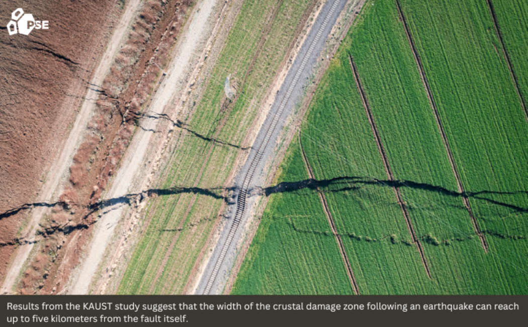
Using the two Kahramanmaraş earthquakes as a case study, KAUST researchers have demonstrated that the surface damage and inelastic deformation away from main faults probably extend more widely than previously thoughtarticle. " id="return-reference-1" href="https://discovery.kaust.edu.sa/en/article/25369/kahramanmaras-earthquake-study-showcases-potential-slip-rate-errors/#reference-1">[1].
“The Kahramanmaraş earthquakes offered us a unique opportunity to gain insights into details of the co-seismic surface displacement,” says Jihong Liu, postdoctoral fellow in KAUST’s Crustal Deformation and InSAR Group, who carried out the study in collaboration with colleagues from KAUST and IPGP in France. “Our results suggest that the width of the crustal damage zone can reach up to five kilometers from the fault itself, rather than just a few hundred meters as suggested by previous case studies.”
Large earthquakes occur when two tectonic plates that are stuck together move suddenly, instead of moving steadily past one another a few centimeters per year. This sudden slip, which yields meter-scale movement within seconds, causes extensive crustal damage. This damage is not just in the immediate vicinity of a plate boundary or fault, but also “off-fault damage” (OFD) away from the main fault. Measuring OFD accurately is a critical element of estimating fault slip rates and earthquake cycles, yet most case studies of major earthquakes appear to have significantly underestimated OFD.
The team used image data from Synthetic Aperture Radar (SAR) satellites to quantify the OFD and 3D surface displacement caused by the two earthquakes. They used images taken before and after the two earthquakes.
“Radar satellites have transformed the study of earthquake zones, enabling us to visualize and analyze large areas in depth without requiring field observations,” says Liu.
Read more at KAUST Discovery.